Utjulik 2000 Expedition Report
Executive Summary
One element of the St. Roch II Voyage of Rediscovery was to continue the search for the wreck, presumably of one of Sir John Franklin’s vessels, which had been reported in Inuit testimony as lying somewhere near the west coast of the Adelaide Peninsula (Utjulik).
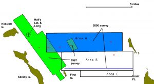
The search area was largely defined by the testimony given to Charles Francis Hall (1869) and Frederick Schwatka (1879), supplemented by prior survey work by the Canadian Armed Forces (Project Ootjoolik – 1992) and a partial survey completed in 1999 by the Canadian Coast Guard/Eco Nova Franklin 150 Expedition (see chart in results section).
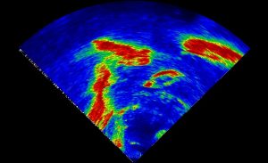
It was determined that the Nadon (St. Roch II) with its shallow draft and stable catamaran design would prove a perfect survey vessel in the uncharted waters, while the escort vessel Simon Fraser provided technical and logistic support. In practise each vessel proved eminently suitable to its tasking. The survey was conducted using the Kongsberg/Simrad SM2000 forward-looking sonar mounted on the side of the Nadon. This high-definition sonar has an effective range of 400 yards, and was able to distinguish bottom features with 2m resolution.

The survey personnel consisted of Mr. David Woodman (search co-ordinator), Dr. George Hobson, Mr. Robert Asplin (Kongsberg/Simrad) and Dr. Mark Treverrow (Department of Fisheries and Oceans). Dr. Treverrow had accompanied the expedition since Alaska, while the others joined the expedition in Cambridge Bay, NWT on August 11th; all four departed after completion of the survey on August 22nd.
Equipment installation and trials were conducted in Cambridge Bay on August 14th and 15th and on-site operations were conducted from the 16th to the 20th. Dr. Hobson directed crew members from the Simon Fraser in shore searches of nearby coasts to determine whether there were any signs of European presence or debris which could direct the survey efforts.
Search rationale
The American explorer Charles Francis Hall reported that one of Franklin’s ships had come to rest “very near O’Reilly Island a little eastward of the north end of said island.” At a later date Hall had a native point out the position on a nautical chart and reported that the wreck was located “near O’Reilly Island, lat. 68°30’N, long. 99°.” This latter identification is confusing as the modern O’Reilly Island lies somewhat to the south of the position given, which is approximately seven miles north west of modern Grant Point near Kirkwall Island.
The most detailed description of the wrecksite was given to the Schwatka expedition (1879). Three accounts of this expedition exist, and the relevant sections of each is reproduced below:
Klutschak – “Only one person, a man of 60-70 years by name of Ikinilik-Petulak, had himself come into contact with one of the [Franklin] expedition’s ships. He was one of the first people to visit a ship which, beset in the ice, drifted with wind and current to a spot west of Grant Point on Adelaide Peninsula, where some islands halted its drift … The credibility of these reports was later enhanced when confirmed by similar statements by others.”
Gilder – “Ikinnelikpatplok [told] of a big ship which was frozen in the ice near an island about five miles due west of Grant Point, on Adelaide Peninsula. They had to walk out about three miles on smooth ice to reach the ship.”
Schwatka – “old Ikinnilik-Puhtoorak … told Ebierbing that the next time he saw a white man was a dead one in a large ship about eight miles off Grant Point … When the ship finally sank her masts stuck out of the water…”
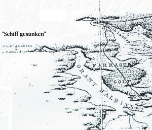
Although these accounts must be used with caution – the descriptions are obviously filtered through European lenses as the Inuit had no conception of either “west” or “miles” – they remain the most specific clues on record. The Inuit accounts do give a good  starting point (Grant Point) and provide some other clues (“near an island” – water depth < mast height), as well as offering hope that the wreck remains upright on the bottom and well preserved (most of the shore debris later recovered consisted of boxes and small items). A chart accompanying Klutschak’s book confirmed that the ship sank (“schiff gesunken”) near and to the west of an island due west of Grant Point.
It was intended to search areas adjoining those surveyed in 1997, and to complete detailed search around the highest priority targets identified in 1992. As the survey time would be limited by other requirements of the Voyage of Rediscovery it was apparent that only a limited search area could be investigated during the 2000 season. It was felt that the balance of probabilities favoured the Kirkwall/Grant Pt. area and it was decided to concentrate on this northern search area.
As the Inuit indicated that the vessel came to rest three miles out in flat ice it was decided to center the search area on the intersection of arcs drawn on a 3 mile radius from the probable islands. This gave an area designated A of 240 Nm2 . On the expectation that this distance might have been overestimated two supplementary areas (B – 112 Nm2, and C – 80 Nm2) were defined if time allowed.
Results
During the on-site period sonar survey was conducted for a total of 44 hours. Approximately 202 Nm of lines were run on a 200 yard spacing resulting in coverage of 16 square nautical miles. Most of area A was completed, and one and a half lines at the south of Area B (run due to weather).

Fig. 1: Combined search results for 1992 (red targets), 1997 (green boxes) and 2000 (blue).
The previously-uncharted ocean bottom was found to be a relatively featureless plain averaging 27m with isolated shoals rising to less than 10 metres on the extensions of shore features and near islands. Four possible targets were found, but all were found to be geological. The locations of these targets were:
1. 68 25.113N 98 53.561W
2. 68 26.53N 98 43.08W
3. 68 28.67N 98 55.828W
4. 68 28.820N 98 45.526W
All targets were surveyed from multiple directions by sonar, and targets 1 and 3 were also surveyed by a towed underwater camera.
Shore parties thoroughly surveyed the un-named island to the southwest of Grant Pt. and the northwestern point of Grant Pt. itself. Although the shores were found to be liberally covered with driftwood and debris, nothing was found which was definitively from the Franklin era. The most interesting items seen were a large piece of wood (possible planking of Douglas Fir) and an oar.
